undefined
Posts
undefined
Followers
Multi-Threat Storm With Damaging Winds, Heavy Rain Will Start Thanksgiving Week: Update
By Joe Lombardi,
2 days agoA stormy start to Thanksgiving week could deliver a second complication for Northeast travelers, with a chance of wintry weather following heavy rain and strong winds from a potential tropical storm.
The National Weather Service expects a coastal storm to bring rain across the region Sunday, Nov. 22, into Monday, Nov. 23. If it strengthens into a named storm, it will be called Kyle.
A separate system could arrive Wednesday night, Nov. 25, into Thanksgiving Day, Thursday, Nov. 26, though its track remains highly uncertain.
The first round could bring 1 to 2 inches of rain across the Philadelphia region, including nearby New Jersey and northeastern Maryland, with locally higher totals possible, according to the NWS Mount Holly office. Southern New England could receive 1 to 3 inches.
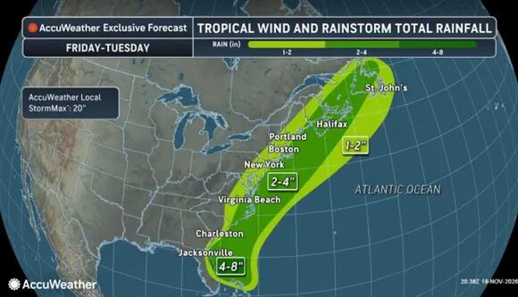
Projected rainfall totals of 2 to 4 inches are expected in parts of the coastal Northeast from Friday, Nov. 20, through Tuesday, Nov. 24.
AccuWeatherWind forecasts differ substantially. The NWS Boston office has lowered its expectations to coastal gusts of 25 to 45 mph. It anticipates limited coastal flooding impacts, while AccuWeather’s outlook calls for potentially damaging gusts.
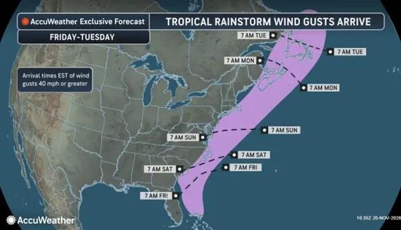
Gusts of at least 40 mph could advance north near the East Coast from Sunday, Nov. 22, into Monday, Nov. 23, according to this forecast.
AccuWeather“Wind gusts of 40-60 mph are forecast for Long Island and southeastern New England from Sunday to Monday and in Nova Scotia and Newfoundland early next week,” AccuWeather says. “Gusts of 60-80 mph may occur in Cape Cod, Nantucket, and Martha’s Vineyard.”
Its wind graphic shows gusts of at least 40 mph advancing north near the coast Sunday into Monday, including offshore areas. Its rainfall graphic places the heaviest rain near Virginia and the Mid-Atlantic Sunday, then farther north into New England by Monday.
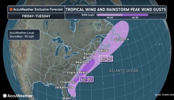
Peak gusts of 40 to 60 mph are forecast for Long Island and southeastern New England from Sunday, Nov. 22, into Monday, Nov. 23.
AccuWeatherThe broader rainfall outlook spans Friday, Nov. 20, through Monday.
“A general 1-4 inches of rain will fall spanning Friday to Monday from northeastern Florida to southeastern New England and in part of southeastern Canada,” AccuWeather noted.
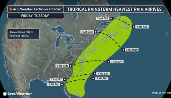
The heaviest rain is forecast to move through the Mid-Atlantic on Sunday, Nov. 22, then toward New England into Monday, Nov. 23.
AccuWeatherColder air follows. Southern New England’s daytime temperatures could fall from the 60s Monday into the 40s Tuesday, Nov. 24, with overnight readings dropping below freezing.
That sets up the second concern: a low chance of snow or ice at the start of the Thanksgiving Eve system across interior southern New England. The NWS also allows for an initial wintry mix inland from New York City.
Rain remains the favored outcome for much of the region. A widespread Thanksgiving Eve snowstorm is not the current NWS forecast, and snowfall amounts remain uncertain.
Check back with Daily Voice for the latest updates.
 Add to Preferred Sources


