undefined
Posts
undefined
Followers
Nor'easter: System Sparks Tornado Warnings Across Northeast, Mid-Atlantic
By Joe Lombardi,
6 days agoConditions have steadily deteriorated across the Northeast as a strengthening storm sweeps through.
The National Weather Service expects rain to intensify Thursday evening, Nov. 12, and continue into Friday, Nov. 13, as the potential Nor'easter moves offshore. The timing puts evening travelers in the path of downpours before winds strengthen overnight.
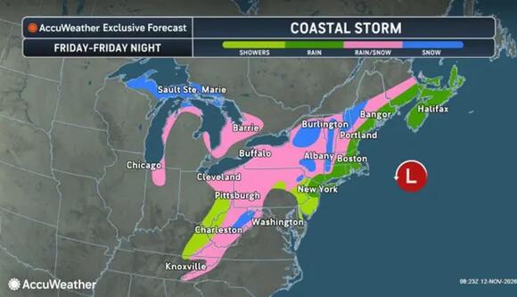
Rain favors the coast Friday, Nov. 13, into Friday night, while inland areas could see a mix of rain and snow as the storm strengthens offshore.
AccuWeatherThe unusual mid-fall Nor'easter triggered multiple tornado warnings across the Northeast and Mid-Atlantic on Thursday, impacting major metropolitan areas from Delaware to New York City.
Strong wind shear and atmospheric instability fueled rotating severe thunderstorms along the I-95 corridor, prompting tornado watches for parts of Pennsylvania and New Jersey through Thursday evening.
The NWS predicts coastal rain chances to increase by midafternoon. Locally heavy downpours could cause brief flooding in urban areas and places with poor drainage, though the overall flash-flood threat remains low.
Rainfall should generally total 0.5 to 1.5 inches, with isolated amounts approaching 2 to 3 inches. Lighter rain continues overnight and through much of Friday before tapering Friday night.
New York City, Long Island, and coastal Connecticut could see gusts of 25 to 30 mph. Minor coastal flooding is possible during Thursday’s and Friday’s daytime high tides.
Southern New England’s steadiest rain should spread in around late afternoon and evening, according to the NWS Boston office. Most communities face cold rain, but the Berkshires, Worcester Hills, and possibly Connecticut’s hills could turn snowy.
Higher terrain could receive up to 2 inches of slush, with a low chance of 3 inches. Farther south, higher elevations well north and west of New York City could see a mix of wet snow, but little or no accumulation is expected.
AccuWeather forecasts rain for Washington, DC, Philadelphia, New York City, and Boston. Its snowfall map shows 1 to 3 inches in selected inland areas and pockets of 3 to 6 inches farther north.
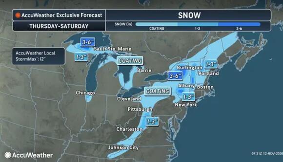
Snowfall projections for Thursday, Nov. 12, through Saturday, Nov. 14, show coatings to 1 to 3 inches inland, with pockets of 3 to 6 inches farther north.
AccuWeatherAccumulation remains elevation-dependent. The Poconos and Adirondacks are among the areas with snow potential.
AccuWeather expects Nor'easter conditions mainly as the storm moves away. Cooling within the storm will help produce mountain snow.
Drier weather returns to much of the region Saturday, Nov. 14. However, inland snow showers could linger into Sunday morning, Nov. 15, with reduced visibility in spots.
Check back to Daily Voice for the latest updates.
 Add to Preferred Sources

