undefined
Posts
undefined
Followers
Potential Nor'easter Could Bring Season’s First Snowfall In Spots
By Joe Lombardi,
8 days agoThe season’s first snowflakes could reach more Northeast communities this week as a developing storm meets an incoming push of colder air.
The National Weather Service is monitoring Thursday, Nov. 12, through Saturday, Nov. 14, for a potential Nor'easter that could bring rain and possible snow. Confidence is high in a cooler pattern, but the storm’s track and precipitation types remain uncertain.
The strongest signal for accumulating snow is in the mountains of northern and western Pennsylvania. The NWS State College office expects rain to change to snow late Thursday into Friday, Nov. 13, particularly across the northwestern mountains and Laurel Highlands.
Farther northeast, higher elevations also have a better chance. The NWS Boston office says wet snow could reach the eastern Berkshires and Worcester Hills, though timing and impacts depend on the storm’s evolution.
AccuWeather identifies Pittsburgh, Syracuse, and Binghamton as places that could see their first flakes. The Poconos and Catskills also face a risk of snow.
“This storm will likely bring the first snowflakes of the season to many locations, though the exact track and intensity of the storm will dictate where,” AccuWeather Senior Meteorologist Adam Douty said. “Areas from the interior of the Northeast to the central Appalachians look like the most likely areas to see snow, though outside of higher elevations, snow should struggle to accumulate.”
For New York City, northeastern New Jersey, and southern Connecticut, the NWS forecast favors rain. Wet snow could mix in well inland at higher elevations Friday night into Saturday, but confidence is low.
Across Maryland and northern Virginia, the NWS Baltimore/Washington office favors rain east of the mountains. The Alleghenies have thebestt chance of accumulating snow, with some mountain snow showersthat could lingerg Saturday.
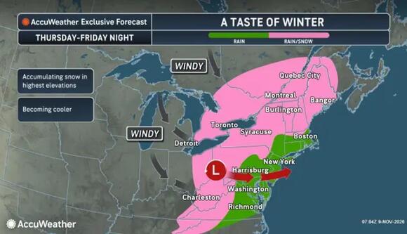
A mix of rain and snow is expected Thursday night, Nov. 12, into Friday, Nov. 13, for the locations shown in pink, with accumulation possible at the highest elevations.
AccuWeatherAccuWeather’s accompanying graphics show an inland rain-and-snow zone Thursday through Friday night, with accumulation favored at the highest elevations and windy conditions as colder air advances.
Snowfall amounts remain uncertain. Some forecast scenarios bring a wetter storm, while others keep it farther offshore and leave parts of the Northeast considerably drier.
AccuWeather's broader outlook projects the season’s coldest air late this week, temperatures 5 to 15 degrees below historical averages, and frost potential extending into the South.
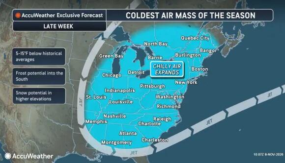
The season’s coldest air could arrive late this week, with temperatures 5 to 15 degrees below historical averages and frost potential extending into the South.
AccuWeatherCheck back to Daily Voice for the latest updates.
 Add to Preferred Sources
