undefined
Posts
undefined
Followers
More storms possible Thursday afternoon in Eastern Iowa
By Fern Alling,
2026-06-11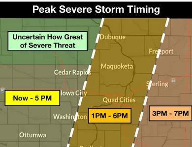
Storms that began Thursday morning will likely last into the afternoon, according to the Quad Cities National Weather Service Forecast office.
The morning storm system brought 30-50 mph winds, with a maximum wind speed of 69 mph in Waterloo around 10 a.m. according to meteorologist Connor Delaune with the NWS forecast office. No tornadoes were reported as of noon.
Most of the morning’s severe threat has ended, Delaune said, but the potential remains for more storms to develop in the afternoon. Delaune said tornadoes, quarter-sized hail and widespread 40 mph wind gusts are possible in the afternoon to mid-evening.
Peak storm severity is expected to vary by location. Cities like Cedar Rapids, Iowa City and Ottumwa are predicted to see the worst of developing storms through 5 p.m. As it moves eastward through the Quad Cities, poor weather is expected in the easternmost part of the state from 1-6 p.m.
While the initial storm has subsided, Delaune said the supercell storms anticipated to form in its wake are more prone to develop tornadoes. The area’s tornado watch will be in effect until 3 p.m.
Delaune said he is unsure how far north the severe weather will reach, especially north of Highway 30 near Independence and Waterloo.
Rain from the storm could cause flash flooding.
Meteorologist Mindy Beerends, who heads the Quad Cities NWS forecast office, said people in affected areas should monitor the weather through multiple channels, such as a combination of text message updates and news media sources. The NWS recommends people in affected areas and places in the storm’s path seek shelter when the storms develop.
Beerends said the office has not received many reports from weather spotters, which can help meteorologists understand the storm’s impact on the ground. She said trained spotters and members of the public can share their observations with the Quad Cities NWS Forecast Office by emailing nws.quadcities@noaa.gov or messaging them on Facebook at National Weather Service Quad Cities Iowa/Illinois or on X @NWSQuadCities.
 Add to Preferred Sources