undefined
Posts
undefined
Followers
Big storm system could roll through Minnesota next weekend, with snowflakes possible
By Joe Nelson,
6 days ago
Snow is going to fall in most of Minnesota eventually, but it remains uncertain as we inch closer to Thanksgiving and December. However, the National Weather Service is beginning to talk about the potential for some snowflakes next weekend.
Is it going to happen? Maybe. Will it be a lot if it does snow? Probably not.
Here’s what Sunday’s forecast discussion from the Twin Cities office of the National Weather Service says about Thursday through next weekend:
“This will be the period with the more active weather. There is a low chance event Wednesday night into Thursday morning and a high chance event late Friday into Saturday,” the discussion reads.
The first opportunity for precipitation will be all rain, and not much of it, as a system moves through Wednesday night through Thursday morning. The bigger storyline for the Wednesday-Thursday system will be a chance to set new low temperature records in parts of northern Minnesota. No, not cold records, but record-warm low temps.
Weather+ exclusive: ‘Imminent winter doom’? What’s in store for Thanksgiving week?
The Nov. 18 record-warm low temperature in Brainerd is 43 degrees (2012). The current forecast low is 42. In Duluth, the record-warm low temperature is 39 on Nov. 19, with the current forecast calling for a low of 37. It’ll be close.
“With the warm air, clouds, and precipitation, both Wednesday and Thursday have a potential to set new warm low temperature records at a few of our climate says,” says the Duluth office of the National Weather Service.
The second chance for precipitation is where things get interesting over the weekend.
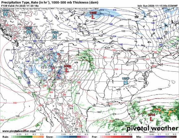
“This second chance will have both a larger scale wave aloft and much greater moisture,” the forecast discussion says, noting that a lighter wave of moisture could be followed by a large wave.
The discussion continues, saying the storm track is still up in the air, but it should keep central and southern Minnesota in the warm sector, thus favoring rain over snow. But that could change as cold air wraps into the backside of the storm as it moves to the east.
“This will bring our [warm-up] to an end and we could see some snow mix in, especially in parts of central Minnesota,” the NWS Twin Cities says. “While snow looks possible at the end, accumulations look unlikely at this time.”
Let’s take a look at some models
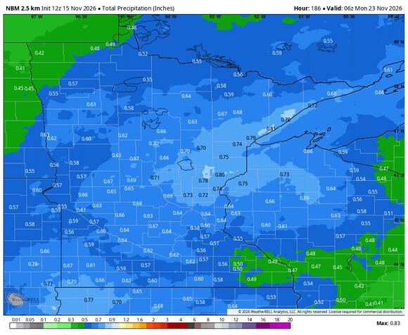
The National Blend of Models (NBM) shows widespread precipitation totals between a half inch and an inch over the next week, with most of it falling Friday-Sunday.
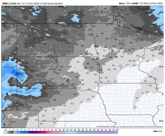
You can also see that the NBM is currently putting some snow in the air.
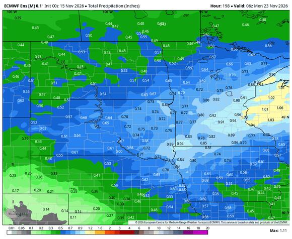
The European ensemble (average of dozens of model outputs) puts the heaviest precipitation right through the Twin Cities and into central Wisconsin.
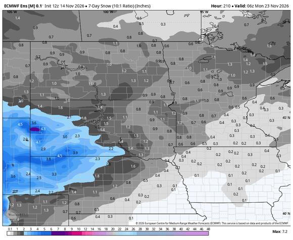
The Euro isn’t showing a lot of snow through next weekend, but it is showing potential for flakes to be flying as the cold side of the storm influences the wrap-around moisture the NWS mentioned in the forecast discussion.
Related Articles
- Snow could arrive before Thanksgiving, but Minnesota’s ‘polar vortex’ hype is overblown
- ‘Imminent winter doom’? What’s in store for Minnesota around Thanksgiving?
This story was originally published by Bring Me The News on Nov 15, 2026, where it first appeared in the MN Weather section. Add Bring Me The News as a Preferred Source by clicking here.
 Add to Preferred Sources


