undefined
Posts
undefined
Followers
AccuWeather: Blustery and chilly
By Eyewitness News,
5 hours ago
A powerful storm that swept through the Tri-State Area on Thursday left behind flooding, hail, damaging winds and even a confirmed tornado in southern New Jersey. The National Weather Service confirmed an EF-1 tornado in Burlington County, near Bordentown Township, after surveying storm damage. The tornado touched down around 4 p.m., carving a path about 1.5 miles long and 100 yards wide with peak winds estimated at 100 mph. Survey crews found collapsed walls on a farm building, damage to a home's roof, a school roof covering torn away and overturned farm equipment.
The storm brought widespread rainfall totals of a half-inch to 2 inches across much of the region, with some areas of Queens picking up 3 to 4 inches of rain. Residents also reported frequent lightning, large hail and flooding in poor-drainage locations, along with minor to moderate coastal flooding. Higher elevations in the region saw accumulating snow, including up to a foot in portions of the northern Catskills, while some local higher elevations received 2 to 3 inches.
In the wake of the storm, the coldest air of the season has settled in, bringing a much more November-like feel.
The weekend will be brisk and chilly, with highs remaining in the 40s. Saturday will feature a mix of clouds and limited sunshine, along with the chance of a spotty sprinkle or flurry in higher elevations. Gusty winds could exceed 20 to 25 mph, making it feel more like the 30s at times.
Sunday looks brighter with lighter winds and temperatures in the upper 40s.
A longer stretch of dry weather is expected next week. Temperatures will gradually moderate, reaching the mid-50s by Tuesday and climbing back to around 60 degrees by the second half of the week.
The latest AccuWeather forecast
Meteorologist Lee Goldberg has the weekend forecast from AccuWeatherTHE 7-DAY FORECAST
Saturday
Blustery and chilly. High 45Sunday
Bright but brisk and chilly. High 49Monday
Partly to mostly sunny. High 53Tuesday
Bright and dry. High 55Wednesday
Plenty of sunshine, milder. High 59Thursday
Sunny and mild. High 60Friday
Sunny and mild. High 61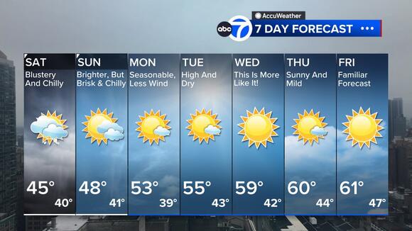
Follow the Weather or Not podcast with Lee Goldberg
Please fill out the form below to submit weather photos and videos.
Terms of use apply.Check AccuTrack RadarAir Quality TrackerNWS Advisories, Watches and WarningsSchool closings and delaysFor weather updates wherever you go, please download the AccuWeather app.Follow chief meteorologist Lee Goldberg, Sam Champion, meteorologist Brittany Bell, meteorologist Jeff Smith, and meteorologist Dani Beckstrom on social media.
 Add to Preferred Sources
